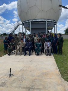
The National Remote Sensing Centre (NRSC) continues to position itself as a national leader in advanced geospatial technologies following the successful hosting of a five‑day HR3D Buckeye Data Training held from 23rd to 27th March 2026 at the Ground Receiving Station, Chibombo District.
The high‑profile event was officially opened by the Permanent Secretary, Ministry of Defence, highlighting Government’s strong commitment to the adoption of cutting‑edge geospatial technologies in support of national security, disaster risk reduction, and sustainable development. The officiation marked a significant vote of confidence in NRSC’s growing strategic role within Zambia’s geospatial and defence ecosystem.

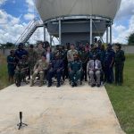


The training was delivered by technical experts from the United States Army Geospatial Centre and forms part of a multi‑level capacity‑building programme, with an advanced phase scheduled for July 2026. Participants were drawn from the Zambia Army, Zambia Air Force, Zambia National Service, and NRSC, reinforcing NRSC’s mandate as a national hub for geospatial capacity building and inter‑agency collaboration.
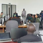
At the core of the programme was HR3D Buckeye data, a state‑of‑the‑art, high‑resolution 3D dataset generated from airborne LiDAR and electro‑optical sensors. The technology provides highly detailed surface and elevation information, bridging the gap between satellite imagery and ground‑based surveys. Participants were equipped with the skills to process and analyse this data using QGIS, an open‑source Geographic Information System widely adopted for advanced spatial analysis.
The training combined theory with intensive hands‑on practical sessions covering:
- Interpretation of high‑resolution LiDAR imagery
- Generation of Digital Surface Models (DSM) and Digital Terrain Models (DTM)
- Raster and vector data handling
- Terrain and elevation analysis
- Practical applications in flood mapping and disaster analysis
The skills gained are directly aligned with NRSC’s core functions, including flood mapping and monitoring, infrastructure assessment, land‑use planning, terrain analysis, and environmental monitoring. The effective utilisation of Buckeye data is expected to significantly enhance the accuracy, precision, and impact of geospatial products produced by NRSC in support of evidence‑based national planning and decision‑making.
Despite varying levels of prior GIS experience among participants, the programme achieved notable success through strong facilitation, peer learning, and continuous technical support from both the instructors and NRSC officers. The collaborative learning environment strengthened not only technical competencies but also institutional cooperation among participating agencies.
The successful completion of the HR3D Buckeye Data Training, officiated at Permanent Secretary level, represents a significant institutional score for NRSC and a major stride in Zambia’s journey towards advanced, data‑driven geospatial intelligence. As preparations begin for the next phase of training, NRSC remains firmly committed to building national expertise and delivering high‑quality geospatial solutions that support socio‑economic development, national security, and resilience.